Introduction
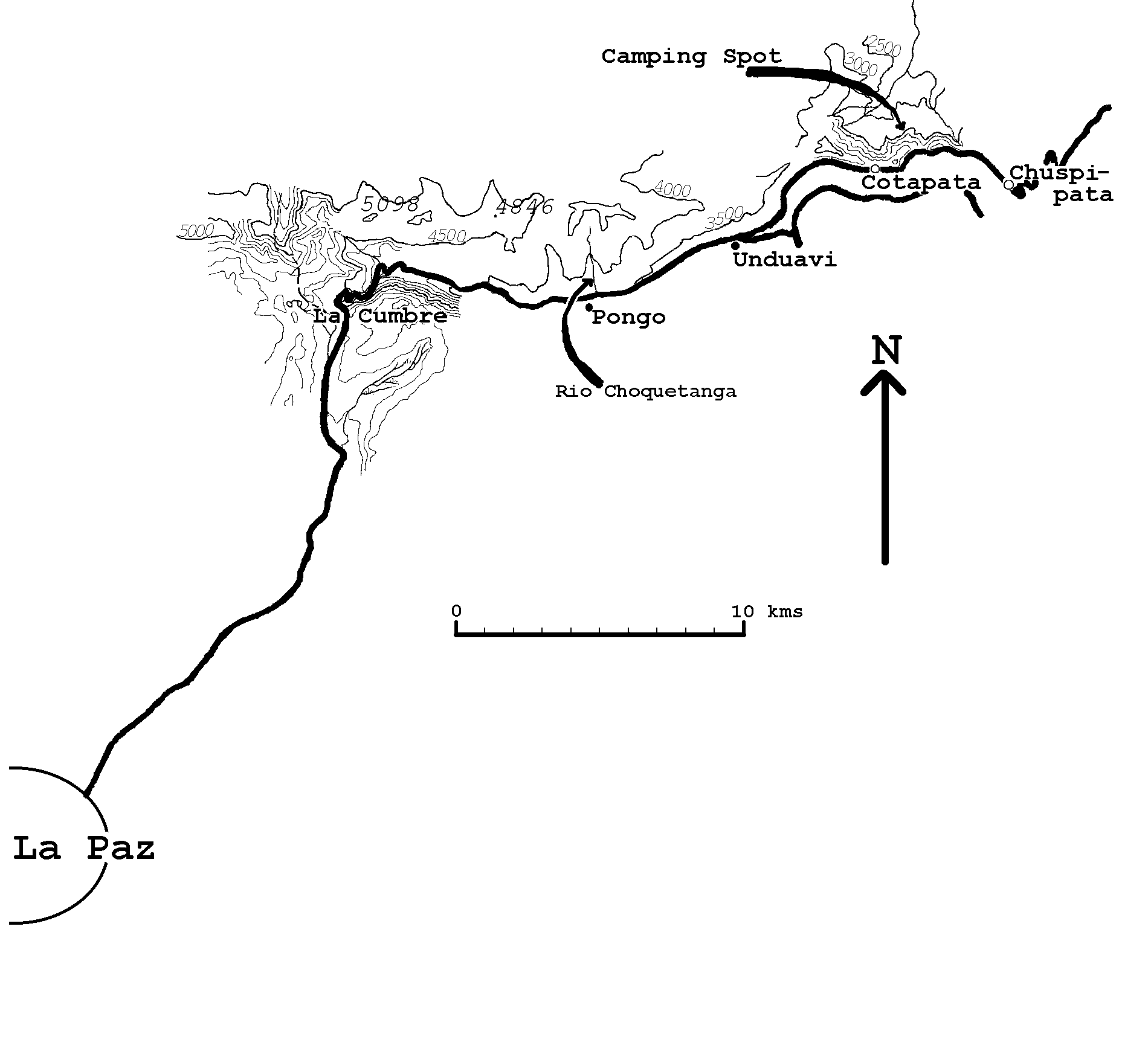
Within a 45 minute drive from the city of La Paz, the birding sites described below offer quick access and some excellent birds. Both sites are located along the (paved!) highway to the Yungas, on the eastern slopes of the Cordillera Real, one at 3650 - 4100m and the other at 3000-3300m. Habitats at the higher site are soggy alpine grassland and an extensive moss- and Polylepis-covered boulder and scree slope. The habitat at the lower site is low, wet montane forest and (mainly) disturbed habitats.
Being located high on the eastern slopes of the mountain range, these sites have fog and rain on most days, especially so in the rainy season (November-April). During that time of the year, it is best to go only for the early morning. The clouds come in quite early on most days (at nine o ''clock or so), and usually it starts raining soon after. I never visited during the dry season, but it should be more comfortable then.
I visited both sites in December '92/January '93, together with Rolf de By. I visited them again in November/December '93 and January '94, each site three times. And again, both sites once, in December 1996 with Tom Gullick.
Access
The sites can easily be reached by public transport, and it is usually no problem to get a ride back. This is one of the busiest roads in the country, because all the transport from the city of La Paz to the Yungas and the eastern lowlands passes over this single road. Most of the buses leave from Villa Fatima early in the morning. Fast minibuses to Coroico leave at 08.30am and 09.00am, which is a bit late. It may be best to buy tickets the day before. An alternative is to go by taxi, which is not so expensive if there are several of you. It should be possible to rent a taxi for the morning for Bs 150 to 200. Of course, you have to negotiate a little.
On the way back, I rarely had to wait for more than 15 minutes, but you need some luck of course.
After leaving the city, the road winds up to the pass called "Tres Cruces" (or "La Cumbre", which simply means "The Highest Point"), at about 4700m.
Behind the pass, the road winds down through the long valley of the Rio Unduavi. If there are clouds in the valley, you need probably not bother to continue, as it is almost certain that the sites described below are already wrapped in fog and drizzle.
In the upper reaches of the valley, you may find Short-tailed Finch Idiopsar brachyurus on boulders along the road.
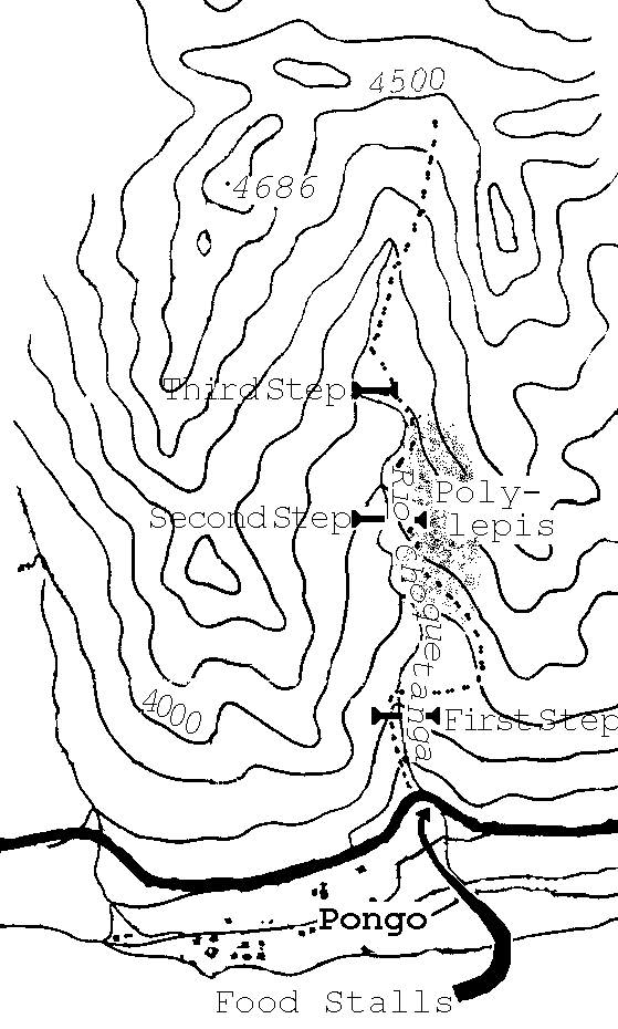
Site 1: The Choquetanga Side Valley. (see photographs)
Eventually, at km. 37, you reach a long line-up of food stalls on the right hand side of the road. This is the place to get off the bus, or to park your car. At the bottom of the valley, to your right, one can see the tiny village of Pongo.

To the Second Step
Just before reaching the food stalls, a little stream comes tumbling down on the left. A trail climbs up the rocks just to the left of the stream, up the first "step" of the little Choquetanga valley. It requires some scrambling. The initial altitude here is 3650m.
Soon one reaches more level ground. Here you must cross the stream. In case of recent heavy rainfall, this crossing requires some jumping ability to keep your feet dry (but what the heck, they''ll get wet in the wet grass later anyway). From here you must head up the slope to your right, until you reach a good trail. Between the stream and the trail there is no obvious connecting trail, only many small fields, most of them not currently in use. After reaching the trail, it leads up to the left, crossing a boulder slope to the top of the second "step".
Before reaching the top of the second step, you may see the
following birds:
- A little party of Paramo Pipits Anthus bogotensis was
always present at the start of the trail (where one can see the
food stalls below) in November and December 1993. One of them was
usually singing.
- Scribble-tailed Canastero Asthenes maculicauda is common
in the tall bunch-grass.
The Polylepis slope (see photographs)
Before reaching the top of the second step, one enters the extensive boulder and scree slope where the rarest birds mentioned in this article live. Huge moss-covered boulders dominate some parts of the slope, other parts have scree with no vegetation at all, and there are all kinds of intermediate stages. The altitude of the slope ranges from 3950 to 4100m. The best part of the slope is that bordering on a level area after reaching the second step and after walking around some low hills, keeping them to your right (it is this area where the Ash-breasted Tit-Tyrant was found, two out of three times, both in 1993 and in 1996).
Numerous patches of Polylepis shrubbery cover the slope, none bigger than 100 square meters. Each Polylepis patch has a thick, spongy moss carpet beneath it, which also covers the "trunks". There are also many Gynoxys shrubs, which are far less mossy than the Polylepis.
That Polylepis still exists here at all must be because of all the slippery boulders. Cattle, horses and llamas simply can not climb this slope. However, the people living in Pongo make sure that no Polylepis shrubs grow higher than about 2 meters, cutting everything higher for firewood. Numerous fresh stubs can be seen all over the slope. Nonetheless, some birds still manage to hang on (see Ref. 5).
Birds to be seen:
- Olivaceous Thornbill Chalcostigma olivaceum. I only saw it once for sure, in a corner of the rock face at the upper end of the central section of the slope. I chased it from (or at least from somewhere near), an empty cup nest in a crevice. Fjeldså and Krabbe mention that Polylepis-Gynoxys woods may be its breeding habitat (Ref. 4).
- Blue-mantled Thornbill Chalcostigma stanleyi. I saw up to three during each visit.
- Line-fronted Canastero Asthenes urubambensis. I saw several during each visit, clambering about on mossy boulders or in the shrubs.
- Stripe-headed Antpitta Grallaria andicola. Rolf de By saw one on January 3 1992, on the central section of the slope, near the grassland at the base, where there are big moss-covered boulders. The bird moved around without being seen for most of the time, but several times it popped up on a boulder to look around. This must be the most easily visible Grallaria (if it really belongs to the genus Grallaria). This species was since seen by several other people.
- Ash-breasted Tit-Tyrant Anairetes alpinus. I rediscovered this Polylepis specialist on November 30 1993. While scrambling up the boulders just after my arrival on the site, I heard some very vocal birdies nearby. Imagine my surprise when I saw four birds of this pretty species only a few meters away! I followed them for a long time, while they moved noisily from one shrubby Polylepis patch to another. I found them again on December 2, but not on January 1.
Two out of three times, both in 1993 and in 1996, it was found in shrubbery close to the level grassland beyond the second step, in an area with big boulders, close to where the trail starts ascending the third step. The third time I found it in a high corner of the slope, where it borders on the rock face, and where there are still a considerable number of relatively tall Polylepis bushes.
This species was observed (and collected) in Bolivia only once before, by Carriker in 1935, at 4100m above km 50 of the Yungas railroad (Ref. 2). The railroad no longer exists, but it seems probable to me that Carriker''s collecting site was the same as the here described site , because 1: if he descended from the train at the village of Pongo, then the Choquetanga side valley is the nearest and most obvious side valley, and 2: the altitudes are the same. The species is also known from several locations in the Peruvian Andes (Ref. 2 and 4), where it is sufficiently rare to be included in the ICBP Red Data Book (Ref. 2).
Some of the other birds seen: Andean Condor Vultur gryphus, Andean Hillstar Oreotrochilus estella, Great Sapphirewing Pterophanes cyanoptera, Tawny Tit-Spinetail Leptasthenura yanacensis, Andean Tapaculo Scytalopus (magellanicus) simonsi, Brown-backed Chat-Tyrant Ochthoeca fumicolor, Cinereous (Plain-capped?) Ground-Tyrant Muscisaxicola cinerea (alpina?), Brown-bellied Swallow Notiochelidon murina, Olive-backed Sierra-Finch Phrygilus punensis, Plumbeous Sierra-Finch Phrygilus unicolor, White-browed Conebill Conirostrum ferrugineiventre.
Suggestions for further exploration
Another bird to find would be Royal Cinclodes Cinclodes (excelsior) aricomae. Buckley collected it in 1876, somewhere in the next east-west valley north of the Rio Unduavi valley (Ref. 2). It was never found again in Bolivia. I searched for it in the Choquetanga valley, but the Polylepis is possibly too low and patchy for it. Still it may be here, as it is not always easy to find (Ref. 3). Later I searched with no luck in the impressive Polylepis stands around Pelechuco (Cordillera de Apolobamba, near the Peruvian border). Still, with the extensive Bolivian Cordilleras hardly explored, I think it must still be somewhere.
It would be interesting to climb up to the top of the ridge at the end of the valley (there is a crashed helicopter on the way, also interesting), and look down into the valleys on the other side, or even climb down if possible. I think there must be comparable sites with Polylepis in other nearby side valleys, possibly only on slippery boulder slopes such as in the Choquetanga valley, because I find it hard to believe that a single family of Ash-Breasted Tit-Tyrant can persist in one isolated location. Also, it was somewhere on the other side that the Royal Cinclodes was found 120 years ago!
Site 2: Cotapata. (see photographs)
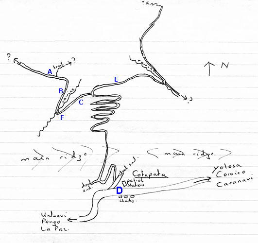
Some 15 km further down the road to Coroico and Caranavi, one reaches the petrol station of Cotapata. From here a narrow disused vehicle track leads down the other (northern) side of the ridge to our birding site, into wet and disturbed montane shrubbery and forest.
The birding site described here lies on the other side of the ridge from the main road (see map), so there was no traffic noise in the 1990s when I was there. However, in 1996 a new road was being constructed on top of the ridge to the east, which will replace the Chuspipata stretch of the La Paz-Caranavi highway (which starts 5 km beyond Cotapata at Chuspipata; a Miami Herald article called that stretch "The Most Dangerous Road in the World"!). The new road will not chase away the Diademed Tapaculos, I think (they also occur along the present highway), nor many of the other species, but it will certainly make for less tranquil birding.
Behind the petrol station, a track leads up and over the ridge (see one of the photos). After two curves, at the foot of an electricity pylon, the track forks: take the track to the right. It leads over the ridge and zigzags down the other side.
In the ninth and last hairpin, a soggy trail turns off to the left. It follows a long disused, well-constructed road-like path, which in one place is cut out of a nearly vertical rock face. Eventually, the trail runs out in dense vegetation. (I wonder who built this road-like path. I saw two similar paths near Pelechuco, both leading to Apolo. According to the locals these Pelechuco-Apolo paths were built by the Spanish, which means they are at least 200 years old! Maybe they are precolumbian, who knows!)
Beyond the turn-off of the trail, the vehicle track turns into a narrow trail on a wide disused path, which really is a continuation of the road-like path mentioned in the previous paragraph. I never followed it to the end, I only know that there is a gold mining operation somewhere further down.
Birding is good everywhere here, including along the track back to the petrol station.

Birds to be seen:
- Sickle-winged Guan Chamaepetes goudotii. First recorded in Bolivia by S.W. Cardiff and J. V. Remsen at Cotapata, it is still only known to occur here and in the nearby Zongo valley. I saw a single bird on November 8 1993.
- Diademed
Tapaculo Scytalopus schulenbergi. This until then
undescribed species was discovered by Bret M. Whitney in 1992 at
Cotapata (Ref. 8). It is one of the commonest birds here, and its
songs are often heard. Playbacking its song lures it easily into
view; playbacking the alarm calls works even better. Making
'psssst' sounds works quite well too. It seems to be most common
in the ravines, but they are found all over the place.
Adults can be
distinguished from neighbouring Scytalopus tapaculos by
the silvery-white, transverse crescent on the forecrown (the
"diadem"), which is most conspicuous when seen from a
frontal angle.
The song is
distinctive: a fast evenly pitched series of about 10 seconds,
starting slowly with throaty syllables far enough apart to be
counted easily, after which it accelerates steadily for several
seconds. Like in the other Scytalopus tapaculos (at least
in Bolivia), songs are emitted at irregular and widely spaced
intervals, which makes it difficult to make good tape recordings.
They always seem to start singing behind your back!
The most often heard
alarm call is a short series of about 10 notes, higher-pitched
than the song, a little rising at the start and descending at the
end, uttered at regular short intervals.
Some of the other birds: Scaly-naped Parrot Amazona mercenaria, Andean Pygmy-Owl Glaucidium jardinii, Rufous-banded Owl Ciccaba albitarsus, Collared Inca Coeligena torquata, Violet-throated Starfrontlet Coeligena violifer, Amethyst-throated Sunangel Heliangelus amethysticollis, Golden-headed Quetzal Pharomachrus auriceps (heard singing lower down), Masked Trogon Trogon personatus, Hooded Mountain-Toucan Andigena cucullata, Bar-bellied Woodpecker Veniliornis nigriceps, Crimson-mantled Woodpecker Piculus rivolii, Light-crowned Spinetail Cranioleuca albiceps, Black-throated Thistletail Schizoeaca harterti, Rufous Antpitta Grallaria rufula, Rufous-faced Antpitta Grallaria erythrotis (heard singing lower down), Streak-necked Flycatcher Mionectes striaticollis, Rufous-headed Pygmy-Tyrant Pseudotriccus ruficeps, Black-throated Tody-Tyrant Hemitriccus granadensis, Ochraceous-breasted Flycatcher Myiophobus ochraceiventris, Crowned Chat-Tyrant Ochthoeca frontalis, Band-tailed Fruiteater Pipreola intermedia, Barred Fruiteater Pipreola arcuata, Andean Solitaire Myadestes ralloides, Great Thrush Turdus fuscater, Collared Jay Cyanolyca viridicyana, Plushcap Catamblyrhynchus diadema, Grass-green Tanager Chlorornis riefferii, Orange-browed Hemispingus Hemispingus calophrys, Superciliaried Hemispingus Hemispingus superciliaris, Drab Hemispingus Hemispingus xanthophthalmus, Three-striped Hemispingus Hemispingus trifasciatus, Golden-collared Tanager Iridosornis jelskii, Moustached Flowerpiercer Diglossa mystacalis, Citrine Warbler Basileuterus luteoviridis, Yellow-billed Cacique Cacicus holosericeus.
Maps
One can buy the following two maps at the Instituto Geografico Militar (I.G.M.) on the Prado in La Paz:
- La Paz 1:250.000, tagged SE 19-3.
- Unduavi 1:50.000, tagged 6045 III. Only a B/W photocopy was available late 1993. One must pay in advance, and it can be picked up the next morning.
References

Photographs of the Chuspipata - Coroico road
.jpg)
Photo 1. View from Chuspipata. ©Rolf de By.
.jpg)
Photo 2. Further down the road, near a place called Sacramento Alto. ©Rolf de By.
.jpg)
Photo 3. Further down the road, near a place called Sacramento Alto. ©Rolf de By.
Back to the main map or the locality list.
|
Bird Songs International Rondostraat 158 7534GN Enschede Netherlands info@birdsongs.com www.birdsongs.com Tel: (+31) 53 4346662 |
This site is maintained by Sjoerd Mayer. If something doesn't work, please tell me!