Inquisivi
See also Jon Hornbuckle's site description on
this page
.jpg)
Photo 1. Inquisivi town from the south. The Rio Khatu
runs in the valley below. The main road (which
eventually goes to Chulumani) can be seen on the other side of
the valley, on the left. The groves which are visible near town consist
mostly of Eucalyptus trees, whereas the dry forest is lower down the slope. © Jon Hornbuckle.
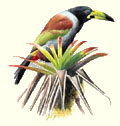
Bolivian Spinetail Cranioleuca henricae is common in the dry forest
in the valley below Inquisivi town (click the small picture to see a larger photo).
.jpg)
Photo 2. The native dry forest in the valley below
Inquisivi, consisting mostly of Schinus molle trees.
Direction of the photo is northwest. The extensive wet cloud forest near
Chojña Khota lies behind the big mountain (the forest which is visible
high on those mountains is also wet cloud forest). The main road to
Quime is not visible, but runs high along the slope on the left.
© Jon Hornbuckle.
.jpg)
Photo 3. Shrubbery, Schinus molle
trees, and eroded terrain along the main road below Inquisivi.
© Jon Hornbuckle.
.jpg)
Photo 4. Shrubbery, Schinus molle
trees, and eroded terrain along the main road below Inquisivi.
© Jon Hornbuckle.
.jpg)
Photo 5. High above Inquisivi town at c. 3300 m, facing north.
Inquisivi town (at 2800 m) is out of view down the slope to the
right, at the same altitude as the main road to Quime of which a
short stretch is visible below the center of the photo. Much
lower down than Inquisivi, the upper end of the dry forest (at
2300 m) is visible with a short stretch of the main road in it (next
to two fields). On the other side of the valley the main road can be seen (it
eventually goes to Chulumani). The gravel bed of the Rio
Khatu (at 2000 m) is also visible. © Jon Hornbuckle.
.jpg)
Photo 6. High above Inquisivi town at c. 3300 m, looking west to the
snow-covered mountains of the Cordillera Quimsa Cruz.
The mountains have little snow, because the photo was
taken in the dry season (although temperatures are lower
than during the rainy season, the sun shines for much of the
time and there is little snowfall).
A: the village of Titi Amaya
B: our camp for several days next to the Rio
Khatu.
C: the hamlet of Isikuni.
D: the valley of the Rio Milluni.
E: the main road to Quime. The village of
Camillaya is around the corner, and not visible.
© Jon Hornbuckle.
.jpg)
Photo 7. High above Inquisivi town at about 3300 m, looking southwest and up the valley
in the direction of the town of Quime. The main road to Quime and La Paz is visible. The highest mountains in the picture are
often covered with some snow during the rainy season, but this
picture was taken in the dry season. © Jon Hornbuckle.

The map is shown at 50% of its size (click to see it at 100%)
Back to the main map
or the locality list.
This site is maintained by Sjoerd Mayer.
If something doesn't work, please tell me!
.jpg)
.jpg)
.jpg)
.jpg)
.jpg)
.jpg)
.jpg)